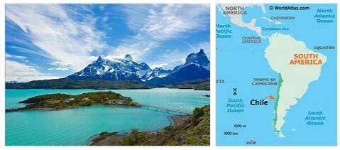
According to mathgeneral, Chile is on the west coast South America and shares its borders in the north with Peru and in the east with Argentina and Bolivia. The territory of Chile also includes the Easter Islands (Rapa Nui), the Juan Fernández Islands, Isla Sala y Gómez and Islas de los Desventurados. Chile stretches along the Pacific Ocean in north-south direction 4,329 km and is on average 180 km wide in east-west direction, the maximum distance is 450 km at Antofagasta.
Here is a detailed topographic map of Chile.
Due to its extreme north-south expansion, Chile crosses 39 degrees of latitude, the resulting diversity of climatic and vegetation zones is increased by large differences in altitude. The sometimes extreme differences are of course also noticeable in the population density and the regional economy.
Chile can be divided into five zones in a north-south direction. A hot, very dry desert with only a few oases. South of Copiapó, this desert turns into a semi-desert. At the height from Llapel to Concepción you will find farmland and wine-growing areas, this is also where most of the Chileans live. The wooded, lakes and rivers area lies between Concepción and Puerto Montt. The entire southern area from Puerto Montt to Cape Horn is sparsely populated. Here fjords, glaciers and numerous wooded islands alternate.
The relief of Chile can basically be divided into three areas: the mountains of the Andes in the east of the country, the transition area (Pampa de Tamarugal and Valle Longitudinal) and the coastal mountains (Cordillera de la Costa) on the Pacific.
The Chilean Andes are usually divided into four regions. One thing these areas have in common is that they rarely (in southern parts) fall below the 2000m contour line.
- the northern Chilean Andes are made up of a chain of relatively young volcanoes that is more than 1000 km long. The highest point in Chile is also reached here: the 6,880 m high Ojos del Salado. This part of the Chilean Andes extends south from the 27th parallel.
- The high cordillera lie between the 27th and 33rd degrees of southern latitude (about the height of Santiago), their peaks reach up to 5,000 m. In the Argentine Andes, the peaks reach between the 32nd and 33rd. Degree of latitude with the Aconcagua its highest altitude. This block consists mainly of Mesozoic-Cenozoic sediments and volcanic rocks and is free of young volcanism.
- Between the 33rd and 42nd Beitengrad there is another 1,000 km long volcanic chain, starting from the 6,800 m high Tupungato. These highly explosive strato volcanoes quickly lose altitude in a southerly direction.
- sedimentary overburden is predominant south of the 42 degree latitude. There are only a few isolated volcanoes in this region, most of which are lower than 3,000 m. The ice ages in particular shaped the landscape here, which can be seen in the multitude of glacial lakes and fjords.
The transition area between the mountains of the Andes and the coastal cordillera can be divided into two regions: the northern Pampa de Tamarugal and the south-central longitudinal valley. The Pampa de Tamarugal reaches an average height of 1,000 m between the border with Peru and the approximate height of Copiapó.
The Valle Longitudinal (also called Valle Central) begins at about the height of Santiago (32nd degree of latitude) and reaches the Pacific Ocean at Puerto Montt (41 ° 30’S), where it extends under the sea over the island of Chiloe to the Taitao peninsula (43 degrees latitude). In the south of the Valle Longitudinal (between Temuco and Puerto Montt) one can find numerous landscapes shaped by the Ice Age.
The coastal cordillera stretches through the entire west of Chile with only a small gap in the south of the island of Chiloe. In the northern part (between Arica and Chañaral around 26 degrees of latitude) they are cliffs that sometimes reach a height of more than 2,000 m. Since it is very dry here, rivers could only create a few valleys. Valley systems can only be found south of Chañaral. To the south, the height of the coastal mountains decreases until it is seldom more than 1,000 m high. From the 44th parallel, the coastal mountains become an island chain (Chonos Archipelago).
Chile climate
Summer and winter in the north of Chile are relatively mild with temperatures around 15-25 ° C with only slight seasonal changes. Rain is not a problem for travel here, as northern Chile is one of the driest regions in the world (despite heavy clouds from April to December). Central Chile has much more pronounced seasonal changes with average daily maximum temperatures of 29 ° C from December to February and around 14 ° C in June. Most of the precipitation occurs in winter, but only falls on a few days of the month. Towards the south of Chile rainfall increases dramatically, with a peak in June. Summer temperatures in this region are slightly lower at 20 ° C and can fall into the single digits by the middle of the year.